Mont Ventoux
Some say Mont Ventoux is the hardest of all the mythical Tour de France climbs and rightly so. The mountain achieved worldwide notoriety when it claimed the life of the great English cyclist Tom Simpson, who died here on July 13th 1967 from a combination of a stomach upset, heat exhaustion, alcohol and amphetamines.On the 13th stage of the 1967 Tour de France, a monster 211km stage from Marseille to Carpentras ridden in temperatures in the mid 30's Tom began to weave wildly across the road before he fell down. He was delirious but then in those immortal words, asked spectators to "put me back on my bike!" He then rode to within 1.5km of the summit before collapsing, still clipped into his pedals. Sadly he died in the Helicopter on the way to Carpentras Hospital. Amphetamines were found in his jersey and bloodstream.
There is a memorial to Tom near the summit which has become a shrine to fans of cycling, who often leave small tokens of remembrance there.
In 1970 Eddy Merckx rode himself to the brink of collapse while winning the stage. He received oxygen, recovered, and won the Tour de France.
The current record for ascending Mont Ventoux is held by Spanish cyclist Iban Mayo. In the 2004 edition of the Dauphineé Libéré race a mountain time trial was held from Bedoin to the summit and Mayo climbed the mountain in an unbelievable 55' 51". Unfortunately due to recent developments, almost all of the top 10 fastest times up the Ventoux posted during that time trial are tainted with doping allegations.
Perhaps the most impressive ascent of The Giant was Charly Gaul with his 1h 2m in 1958?
See the full results of the Individual Time Trial in the 2004 Dauphiné Libere race here.
Some great quotes:
"Physically, the Ventoux is dreadful. Bald, it's the spirit of Dry: Its climate (it is much more an essence of climate than a geographic place) makes it a damned terrain, a testing place for heroes, something like a higher hell."
Roland Barthes, French philosopher and bicycle racing fan,
"The Ventoux is a god of Evil, to which sacrifices must be made. It never forgives weakness and extracts an unfair tribute of suffering."
Roland Barthes, French philosopher and bicycle racing fan,
"I fought battles here in a past life."
Dai Parry, (Cwn Carn Paragon Cycling Club, S. Wales) 2km below Chalet Reynard

The Bedoin Route
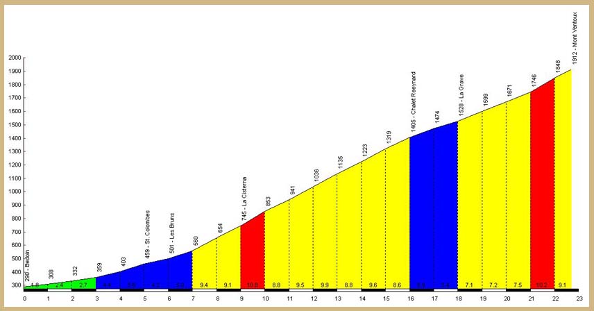
The ascent from Bedoin is the classic way up the mountain. The length of the climb from Bedoin at 300m asl to the summit at 1912m is 21.5km . This gives an elevation of 1612m and an average gradient of 7.5%. This doesn't sound too bad but when you break the climb down into its 3 obvious sections it paints a different picture. Please click here to download a .pdf file of the route profile.
From Bedoin at 300m it is 5.5km to St. Esteve at 541m. This gives an elevation of 241m and an average gradient of just 4.4%.
So why the bad reputation? Well, the next section, the infamous forest has the answer. From St. Esteve at 541m it is 9.5km to Chalet Reynard at 1417m. This gives an average gradient of over 9% for the whole of this section. It is also worth remembrering that this 9% is not constant as there are a few sections as low a 7% and many over 11% and 12%.
The last 6km from Chalet Reynard are much easier than the forest section but also much more exposed and weather dependent. This section has the reputation of being very windy. However it works both ways and quite often a nice tail wind will help you to the top. As you leave Chalet Reynard you have a short steep section but as you round the first bend there is a noticeable drop in gradient with an average of approximately 7% for the next 4.5km. If you are very lucky you will have a tail wind and it will be possible to fly up this part of the climb. If you are unlucky you will be battling into the wind all the way to the top and it will feel like 12% again. The last 1500m from the Simpson Memorial are steep again at 10% but by this time you won't really care.
The Malaucene Route
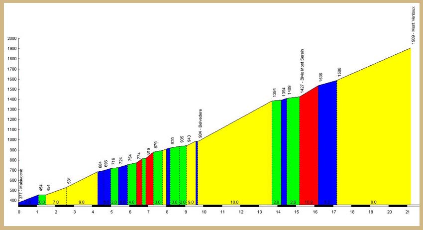
We can argue until the cows come home which is harder, the Bedoin side or the Malaucene side. What we do know is that both sides are long and hard. For a .pdf file of the route profile please click here.
Starting in Malaucene at 360m you have approximately 1km then as you pass the cafe on the right the road steepens to over 9% for 2km to 500m. Here you get some respite with a nice section of 4, 5 and 6% which is the story until the 9km mark.
Here it kicks and the gradient once again goes over 10% (with some 12%).This is a very hard section, as you pass the water tank and the concrete shed the road swings right then left then you can see straight ahead for a kilometre at well over 10%. The road then twists slightly at a layby then a welcome rest section as you pass the mini roundabout and the cafe at Chalet Liotard.
0.75km of steep climbing then a sharp hairpin left leads to a nice long 6 and 7% section with the steep ski pistes dropping down to your left. As you leave the trees you are greeted with a fantastic view of the tower still 250m above your head. The last two hairpins steepen again with magnificent views to the North where on a clear day the Alps form a fantastic backdrop.

The Sault Route
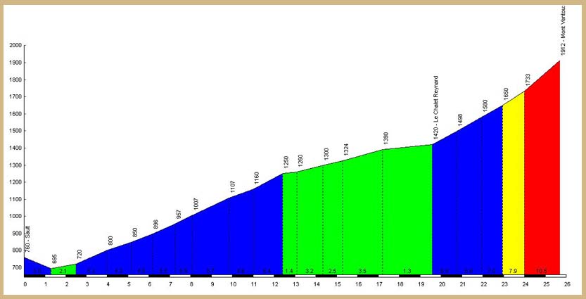
The ascent from Sault is the easiest of the 3 popular ascents. There are two reasons for this. First the elevation is much less because the start of the ascent from Sault is at a height of 694m. Secondly, the overall distance is longer than the other two at 26km. This means that the first 20km of the climb from Sault at 694m to Chalet Reynard at 1417m with a total elevation of 723m, has an average gradient of just 3.6%. You still need to climb the last 6km from Chalet Reynard to the summit but you arrive at Chalet Reynard in much better condition than if you have just slogged up through the forest from Bedoin. Please click here to download a .pdf file of the route profile.
After a short descent out of Sault you start the climb up through the lavender fields then a few short sharp sections lead up into the forest from where it becomes a bit of a boring haul. The road then sweeps left at 1263m where a gentle section trends south to the viewpoint and belvedere at 1327m. From here to Chalet Reynard the gradient is very gentle and the last 2km are almost flat.
The last 6km from Chalet Reynard are exactly the same as the Bedoin route. It is a section that is very exposed and weather dependent and has the reputation of being very windy. On leaving Chalet Reynard there is a short steep section but rounding the first bend you notice a significant drop in gradient with an average of approximately 7% for the next 4.5km. The last part from the Simpson Memorial rears up again and the last 1500 metres are at an average of 10% gradient.

.


